Even hotter days ahead: El Nino expected to turn up heat in April and May, say experts
Temperatures in the next two months could be nudged up further due to the lingering effects of El Nino.
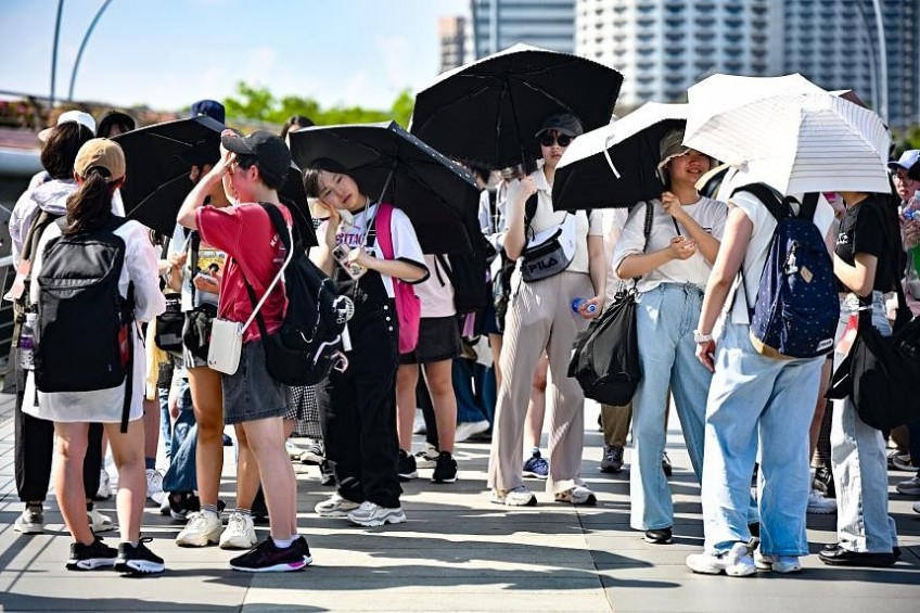
PHOTO: The Straits Times
SINGAPORE - Get ready to sizzle in April and May.
Temperatures in the next two months – usually among the warmest months in the year – could be nudged up further due to lingering effects of the El Nino phenomenon that gripped Singapore from the second half of 2023, experts say.
El Nino is a natural climate phenomenon that brings hotter, drier weather over South-east Asia due to changes in sea surface temperatures and surface winds over the tropical Pacific Ocean.
El Nino conditions are weakening and are expected to taper off by around April or May, said the National Environment Agency’s Meteorological Service Singapore (MSS) in response to queries.
But El Nino is likely to still make its presence felt in Singapore in the form of higher-than-usual temperatures in the months ahead, as heat takes time to transfer from the sea surface to the atmosphere, experts told The Straits Times.
This lingering effect of El Nino is expected to overlap with the traditionally warm months of the year in Singapore, they added.
According to MSS records, May is the warmest month of the year, with an average daily temperature of 28.6 deg C. The average daily temperature in April is 28.2 deg C, while June’s average temperature is 28.5 deg C.
Professor of urban climatology Matthias Roth at the National University of Singapore’s (NUS) department of geography said: “Given that an El Nino event continues to contribute heat after its peak, it is possible that the next few months, which coincide with the warmest part of the year, will experience above-average temperatures.”
The increase in air temperatures usually associated with El Nino events, coupled with the already high humidity in Singapore, will make being outdoors during the months of April to June more uncomfortable, Prof Roth added.
Professor Xie Shang-Ping, an expert in physical oceanography from the Scripps Institution of Oceanography at the University of California San Diego, agreed. He said: “High humidity in combination with high temperatures could cause heat stress.”
An MSS spokeswoman said that while heat stress levels tend to go up with higher temperatures and humidity, other factors – such as wind speed and the amount of radiation from the sun – also need to be considered.
High heat stress levels could lead to an increased risk of heat-related illnesses such as heatstroke, heat exhaustion and heat cramps.
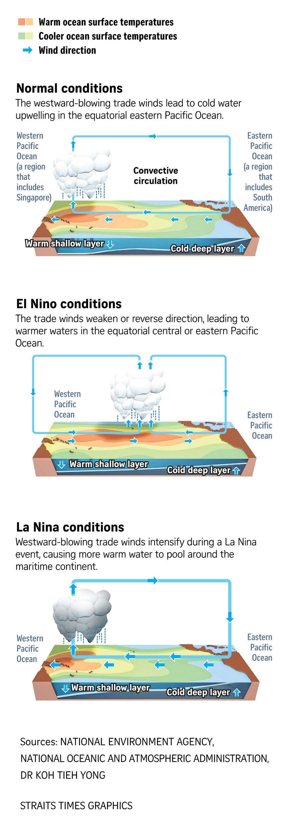
El Nino refers to the warm phase of the El Nino Southern Oscillation (Enso), one of the world’s largest natural climate cycles that influences sea surface temperatures and rainfall patterns.
In the tropical Pacific Ocean, winds blow mainly from east to west. These predictable trade winds, as they are known, keep warm water confined around the maritime continent, fuelling the formation of rain clouds and blessing the region with rain.
But during an El Nino event, trade winds weaken, and the pool of warm water in the west is no longer confined to that region. Instead, a tongue of warm water now extends from west to east.
As the warm water moves towards the central and eastern Pacific Ocean, rain clouds follow, resulting in drier, hotter weather over Singapore.
During a La Nina event – the cool phase of Enso – the opposite happens. Warm water pools around the South-east Asian region, resulting in more rain.
On March 23, the MSS said in its annual climate assessment report that 2023, an El Nino year, was the fourth-warmest year on record. The average temperature of 28.2 deg C in 2023 was tied with two other El Nino years in 2015 and 1997.
The warmest years on record are 2019 and 2016 at 28.4 deg C, and 1998 at 28.3 deg C.
The MSS also warned then that temperatures in 2024 could be higher than in 2023 due to the lingering impact of El Nino.
In 2016 and 1998, the El Nino events ended around April. “Both May 2016 and (May) 1998 were warmer than the long-term average,” MSS added.
The MSS spokeswoman said studies have shown that El Nino’s effects on near-surface air temperatures in the region tend to lag a few months after the changes in sea surface temperatures.
She added: “Part of this lag likely comes from a release of heat from the ocean to the atmosphere over the central and eastern Pacific, which then goes on to affect the atmosphere around the globe.”
Associate Professor Steve Yim, from Nanyang Technological University’s (NTU) Asian School of the Environment and Lee Kong Chian School of Medicine, said air temperature usually peaks a few months after El Nino reaches its maximum strength.
“In early January 2024, El Nino was observed to reach its maximum strength,” Prof Yim said. “The response of the atmosphere to the abnormal warmer sea surface temperature, such as during an El Nino, takes time, because heat takes time to transfer from the sea surface to the atmosphere.”
NUS’ Prof Roth said: “Heat is effectively stored by water and continues to be released into the atmosphere after an El Nino event has peaked.”
Asked if the forecast warmer-than-usual temperatures in 2024 would increase the possibility of transboundary haze in South-east Asia, experts said the risk of forest fires in the region depends on numerous factors beyond just temperatures.
NTU’s Prof Yim said: “A warmer-than-usual situation alone may not increase the risk of transboundary haze, but the situations of drought, warmth and favourable wind together are very likely to facilitate transboundary haze pollution in Singapore.”
The MSS spokeswoman said seasonal climate models are not predicting that another El Nino will form in 2024.
“The southern Asean region is expected to be less dry during the traditional dry season from June to October 2024, than in the corresponding period in 2023, when there were El Nino conditions and a positive Indian Ocean Dipole,” the spokeswoman added.
She was referring to the positive Indian Ocean Dipole (IOD) conditions that beset Singapore in the second half of 2023, contributing to warmer-than-usual temperatures that year.
Similar to El Nino, a positive IOD brings warmer weather to Singapore due to atmospheric and sea-surface temperature variations across the Indian Ocean. In 2023, Singapore experienced a “double whammy” of climate phenomena that nudged up average temperatures.
The spokeswoman added that periods of dry weather can still be expected between June and October in 2024.
“(This) may result in transboundary haze if fires develop in the nearby region and prevailing winds blow the smoke plumes towards Singapore,” she said.
Dr Koh Tieh Yong, co-chair of the Working Group for Asian-Australian Monsoon and World Climate Research Programme, noted that the risk of transboundary haze depends on more than just meteorological factors.
“Every year, the risk of transboundary haze depends to a larger extent on the human activities on the ground: land clearance by burning, preventive irrigation of cleared land by local authorities, on-site policing against illegal agricultural practices,” he said.
ALSO READ: Some schools advise students to wear PE attire amid Singapore's blistering heat
This article was first published in The Straits Times. Permission required for reproduction.